![](/images/other/stat-length.png)
![Excursión Bici de montaña Les Baux-Sainte-Croix - 2024_06_25_cimetière des indigents - Photo](https://media.geolcdn.com/t/1900/400/ext.pjpeg?maxdim=2&url=https%3A%2F%2Fstatic1.geolcdn.com%2Fsiteimages%2Fupload%2Ffiles%2F1524743154velo.jpg)
2024_06_25_cimetière des indigents
fredtruc27
Usuario
![Longitud](/images/other/stat-length.png)
Longitud
39 km
![Altitud máxima](https://static1.geolcdn.com/siteimages/upload/files/1508320355ic_sort_altitude_max_24dp.png)
Altitud máxima
159 m
![Desnivel positivo](https://static1.geolcdn.com/siteimages/upload/files/1508320355ic_sort_den_pos_24dp.png)
Desnivel positivo
473 m
![Km-Effort](/images/other/stat-length.png)
Km-Effort
45 km
![Altitud mínima](https://static1.geolcdn.com/siteimages/upload/files/1508320355ic_sort_altitude_min_24dp.png)
Altitud mínima
68 m
![Desnivel negativo](https://static1.geolcdn.com/siteimages/upload/files/1508320355ic_sort_den_neg_24dp.png)
Desnivel negativo
474 m
![Boucle](https://static1.geolcdn.com/siteimages/upload/files/16400158638029165_repeat_loop_refresh_sync_direction_icon.png)
Boucle
Sí
Fecha de creación :
2024-06-25 15:39:52.573
Última modificación :
2024-06-25 18:30:22.747
![Bici de montaña](https://static1.geolcdn.com/sitytour/trail-icons/202.png)
2h45
Dificultad : Medio
![Escanee este código QR para abrir la excursión en la aplicación SityTrail](https://capi.geolives.com/qq0zvz2zws4bq2lad0pu/sitytour/trails/4102866/qr.png?size=200)
Aplicación GPS de excursión GRATIS
A propósito
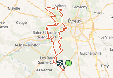
Ruta Bici de montaña de 39 km a descubrir en Normandía, Eure, Les Baux-Sainte-Croix. Esta ruta ha sido propuesta por fredtruc27.
Descripción
les baux ste croix- Asnières- St Sébastien de Morsent - forêt d'Évreux- les Baux Ste Croix
Localización
País:
France
Región :
Normandía
Departamento/provincia :
Eure
Municipio :
Les Baux-Sainte-Croix
Localidad:
Unknown
Salida:(Dec)
Salida:(UTM)
362976 ; 5424251 (31U) N.
Comentarios
Excursiones cerca
![Excursión Bici de montaña Arnières-sur-Iton - La balade des copains - Arnieres sur Iton - Photo](https://media.geolcdn.com/t/375/260/ext.jpg?maxdim=2&url=https%3A%2F%2Fservices.sitytrail.com%2FGeolivesWS%2FDownloadMedia.ashx%3FTrailID%3D103963%26Media%3D6851_2.jpg)
![Bici de montaña Bici de montaña](https://static1.geolcdn.com/sitytour/trail-icons/202.png)
La balade des copains - Arnieres sur Iton
Bici de montaña
Difícil
(1)
Arnières-sur-Iton,
Normandía,
Eure,
France
![](/images/other/stat-length.png)
34 km | 41 km-effort
2h 19min
![](https://static1.geolcdn.com/siteimages/upload/files/16400158638029165_repeat_loop_refresh_sync_direction_icon.png)
Sí
![Excursión Senderismo Les Ventes - Petit circuit de la Pierre de Courcoulée.20/03/23 - Photo](https://media.geolcdn.com/t/375/260/ext.jpg?maxdim=2&url=https%3A%2F%2Fmedia.geolcdn.com%2Ff%2F914b69b2-bbec-487d-b2eb-519e3d4739f2.jpg)
![Senderismo Senderismo](https://static1.geolcdn.com/sitytour/trail-icons/101.png)
Petit circuit de la Pierre de Courcoulée.20/03/23
Senderismo
Muy fácil
Les Ventes,
Normandía,
Eure,
France
![](/images/other/stat-length.png)
3,7 km | 4,1 km-effort
1h 13min
![](https://static1.geolcdn.com/siteimages/upload/files/16400158638029165_repeat_loop_refresh_sync_direction_icon.png)
Sí
![Excursión Otra actividad Les Baux-Sainte-Croix - chemin des postiers en chantier - Photo](https://media.geolcdn.com/t/375/260/ext.jpg?maxdim=2&url=https%3A%2F%2Fservices.sitytrail.com%2FGeolivesWS%2FDownloadMedia.ashx%3FTrailID%3D448902%26Media%3Dfix__20140503122847.jpg)
![Otra actividad Otra actividad](https://static1.geolcdn.com/sitytour/trail-icons/900.png)
chemin des postiers en chantier
Otra actividad
Muy fácil
Les Baux-Sainte-Croix,
Normandía,
Eure,
France
![](/images/other/stat-length.png)
19 km | 22 km-effort
1h 39min
![](https://static1.geolcdn.com/siteimages/upload/files/16400158638029165_repeat_loop_refresh_sync_direction_icon.png)
Sí
![Excursión Otra actividad Le Plessis-Grohan - cimetière allemand - Photo](https://media.geolcdn.com/t/375/260/ext.jpg?maxdim=2&url=https%3A%2F%2Fservices.sitytrail.com%2FGeolivesWS%2FDownloadMedia.ashx%3FTrailID%3D448901%26Media%3Dfix__20140517123528.jpg)
![Otra actividad Otra actividad](https://static1.geolcdn.com/sitytour/trail-icons/900.png)
cimetière allemand
Otra actividad
Muy fácil
Le Plessis-Grohan,
Normandía,
Eure,
France
![](/images/other/stat-length.png)
51 km | 55 km-effort
2h 20min
![](https://static1.geolcdn.com/siteimages/upload/files/16400158638029165_repeat_loop_refresh_sync_direction_icon.png)
No
![Excursión Bicicleta Le Plessis-Grohan - cimetière allemand - Photo](https://media.geolcdn.com/t/375/260/ext.jpg?maxdim=2&url=https%3A%2F%2Fservices.sitytrail.com%2FGeolivesWS%2FDownloadMedia.ashx%3FTrailID%3D302651%26Media%3Dfix__20140517123528.jpg)
![Bicicleta Bicicleta](https://static1.geolcdn.com/sitytour/trail-icons/200.png)
cimetière allemand
Bicicleta
Muy fácil
Le Plessis-Grohan,
Normandía,
Eure,
France
![](/images/other/stat-length.png)
51 km | 55 km-effort
2h 20min
![](https://static1.geolcdn.com/siteimages/upload/files/16400158638029165_repeat_loop_refresh_sync_direction_icon.png)
No
![Excursión Bici de montaña Les Baux-Sainte-Croix - chemin des potiers en chantier - Photo](https://media.geolcdn.com/t/375/260/ext.jpg?maxdim=2&url=https%3A%2F%2Fservices.sitytrail.com%2FGeolivesWS%2FDownloadMedia.ashx%3FTrailID%3D273268%26Media%3Dfix__20140503122847.jpg)
![Bici de montaña Bici de montaña](https://static1.geolcdn.com/sitytour/trail-icons/202.png)
chemin des potiers en chantier
Bici de montaña
Muy fácil
Les Baux-Sainte-Croix,
Normandía,
Eure,
France
![](/images/other/stat-length.png)
19 km | 22 km-effort
1h 39min
![](https://static1.geolcdn.com/siteimages/upload/files/16400158638029165_repeat_loop_refresh_sync_direction_icon.png)
Sí
![Excursión Senderismo Sylvains-lès-Moulins - Circuit du Moulin du Coq - Villez - Photo](https://media.geolcdn.com/t/375/260/ext.jpg?maxdim=2&url=https%3A%2F%2Fservices.sitytrail.com%2FGeolivesWS%2FDownloadMedia.ashx%3FTrailID%3D112487%26Media%3D10663_3.jpg)
![Senderismo Senderismo](https://static1.geolcdn.com/sitytour/trail-icons/101.png)
Circuit du Moulin du Coq - Villez
Senderismo
Fácil
Sylvains-lès-Moulins,
Normandía,
Eure,
France
![](/images/other/stat-length.png)
7,3 km | 8,2 km-effort
1h 49min
![](https://static1.geolcdn.com/siteimages/upload/files/16400158638029165_repeat_loop_refresh_sync_direction_icon.png)
Sí
![Excursión Senderismo Les Ventes - Forêt des Ventes - Photo](https://media.geolcdn.com/t/375/260/ext.jpg?maxdim=2&url=https%3A%2F%2Fmedia.geolcdn.com%2Ff%2Fad607410-9c41-468c-8e4b-988c945aacf4.jpg)
![Senderismo Senderismo](https://static1.geolcdn.com/sitytour/trail-icons/101.png)
Forêt des Ventes
Senderismo
Fácil
Les Ventes,
Normandía,
Eure,
France
![](/images/other/stat-length.png)
5,1 km | 6,1 km-effort
1h 22min
![](https://static1.geolcdn.com/siteimages/upload/files/16400158638029165_repeat_loop_refresh_sync_direction_icon.png)
Sí
![Excursión Senderismo Les Ventes - La tringale - Villalet - Photo](https://media.geolcdn.com/t/375/260/ext.jpg?maxdim=2&url=https%3A%2F%2Fmedia.geolcdn.com%2Ff%2F8ba89c86-5160-406d-8434-a9cc0ad2fe9e.jpg)
![Senderismo Senderismo](https://static1.geolcdn.com/sitytour/trail-icons/101.png)
La tringale - Villalet
Senderismo
Medio
Les Ventes,
Normandía,
Eure,
France
![](/images/other/stat-length.png)
13,5 km | 15,5 km-effort
3h 34min
![](https://static1.geolcdn.com/siteimages/upload/files/16400158638029165_repeat_loop_refresh_sync_direction_icon.png)
Sí